4 P.M. #RADAR UPDATE:
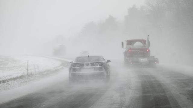
A line of #showers with a few possible #thunderstorms continue to push east through northwest #Wisconsin and towards the #UpperPeninsula.
A brief #downpour and gust of #wind are the additional dangers along with any #lightning.


4 P.M. #RADAR UPDATE:
A line of #showers with a few possible #thunderstorms continue to push east through northwest #Wisconsin and towards the #UpperPeninsula.
A brief #downpour and gust of #wind are the additional dangers along with any #lightning.
NORTHLAND FORECAST FOR APRIL 2, 2025:
A strong #storm system will bring #snow #showers through the #Northland Tuesday night and Wednesday. Some #snowfall rates will be up to 1” per hour at times.
Some #mixed #precipitation will take place over northwest #Wisconsin and the #UpperPeninsula. #Winds will be strong with gusts over 30 mph likely with #temperatures in the 30s.
VIDEO: https://www.fox21online.com/2025/04/01/tuesday-evening-northland-forecast-4-1-2025/
#Snowfall totals will be lower in northwest #Wisconsin and the #UpperPeninsula as the forecasted movement of the #storm system will allow #rain, #freezing rain, and #sleet to mix in with #snow #showers Wednesday.
A #thunderstorm is also not out of the question.


This was at the Mackinac Bridge at about 7:30 this morning. They closed the bridge due to falling ice shortly after we crossed. I-75 from St. Ignace down to about Grayling was wrecked- thousands of trees down. Didn't even get off the expressway because most places have no power.

While forecast #snowfall totals could shift, it is likely the #Minnesota side of the #Northland will see at least 6-inches by Wednesday night. The North Shore will see at least 12-inches in spots.
Minor #ice accumulations, up to 0.1", are possible in northwest #Wisconsin and the #UpperPeninsula.
A #thunderstorm or two also cannot be ruled out for Wednesday.
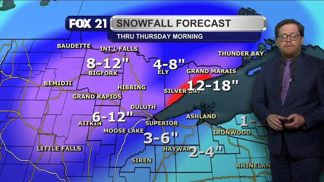
 is for the North Shore to see the highest totals of 10 to 18 inches. Expect 6 to 12 inches over the rest of the Arrowhead, the Iron Range, and the Minnesota side of the Twin Ports regions. 5 to 10 inches is likely in the Rainy River Basin, with 3 to 8 inches in the I-35 corridor and the Wisconsin side of the Twin Ports regions. Snowfall will decrease to 2 to 4 inches for the rest of northwest Wisconsin, with up to 2 inches in the Upper Peninsula.")


The tree is just a little frosty after the ice storm. #tree #IceStorm #michigan #UpperPeninsula

Snowy owl sitting on an electric pole in Rudyard, MI. We saw another one land on another pole further down the road.

Winter isn't over.
Another snowstorm in Michigan's Upper Peninsula over the weekend brought 15+ inches of snow to Houghton.

Winter isn't over for Michigan's Upper Peninsula.
Starting tonight, a winter storm may bring up to 16 inches of snow to the Upper Peninsula.
Happy #Tuesday afternoon from the #Northland!
It's another #seasonal early #spring day with some #clouds and light #winds.
I am watching the next #storm system take shape to our southwest. Northwest #Wisconsin and the #UpperPeninsula will be the areas that see accumulating #snowfall through Wednesday.


4 P.M. #RADAR UPDATE & SNOW TOTALS:
The last of the #snow #showers from a large #storm system are moving out of the #Northland to the east.
As #forecasted, northwest #Wisconsin and the #UpperPeninsula saw the highest #snowfall totals. I expect some of them to increase as new measurements are made.


 include 7.2-inches in Shell Lake, Wisconsin, 7.1-inches in Ironwood, Michigan, 7-inches in Webster, Wisconsin and Herbster, Wisconsin, 6.5-inches in Hayward, Wisconsin, and 6.3-inches in Bayfield, Wisconsin.")
Happy #Wednesday afternoon from the #Northland!
The impact of the large #storm system passing through the United States is moving out to the east. Northwest #Wisconsin will continue to see #snow #showers through this afternoon, with the #UpperPeninsula through the evening.
#Winds remain #breezy throughout the area with #cool #temperatures.

. Winter Storm Warnings remain in effect for Sawyer County until 3 p.m. Wednesday, March 5, 2025 (Central Standard Time), Ashland, Bayfield, and Iron counties until 6 p.m. Wednesday (Central Standard Time), and Gogebic County until 1 a.m. Thursday (Eastern Standard Time).")


HEAVY SNOW FOR SOME:
Round two for the #Northland when it comes to this #strong Colorado low storm system approaching the #GreatLakes will take place Tuesday night and Wednesday.
Northwest #Wisconsin and the #UpperPeninsula will see plenty of #snow. Some spots near #LakeSuperior will receive over 12 inches.


Whoa.
A late winter snow storm is forecast for Michigan's Upper Peninsula beginning Tuesday night.
"The heaviest snow will fall west of Marquette with up to 29 inches of snow falling by Thursday, the weather service said."
Sketch of the Week: Dave’s Home Improvement Center (Week 7, 2025) https://www.davideriknelson.com/sbsb/index.php/2025/02/sketch-of-the-week-young-daves-home-improvement/ #art #Bluey #drawing #newsD #newsF #PureMichigan #sketch #sketching #snow #UpperPeninsula #Winter

NORTHLAND FORECAST FOR FEBRUARY 17, 2025:
The #arctic air is back in the #Northland.
Lows Sunday night will be as #cold as -25°, with #windchills as low as -45° through Monday morning. #Temperatures will hover around 0° for highs Monday afternoon, with a northwest #breeze keeping it feeling below zero.
#Lakeeffect #snow #showers continue for the #UpperPeninsula, with decreasing #clouds elsewhere.
VIDEO: https://www.fox21online.com/2025/02/16/sunday-evening-northland-forecast-2-16-2025/
WEEKEND SNOWFALL TOTALS:
The #snow #showers across the #Northland since Valentine's Day have contained big and fluffy #snowflakes.
Thanks to a northeast #breeze creating #lakeeffect bands, and you get some decent #snowfall totals. Some spots saw 9 to 12 inches of #accumulation.
More lake effect snow showers continue for the #UpperPeninsula through Monday.


 for Ontonagon County. 3 to 10 inches of additional snowfall will take place, with the highest amounts closest to Lake Superior. A Winter Weather Advisory is in effect for Gogebic County until 7 a.m. Monday (Eastern Standard Time) for up to 3 inches of new snowfall.")
Happy #Sunday afternoon from the #Northland!
The weekend #snow #showers are wrapping up for most of the region. Only #lakeeffect bands for the
#UpperPeninsula remain.
It will be back to the #arctic #cold of #winter the next several days, starting tonight.


 from midnight through 10 a.m. on Monday, February 17, 2025. Wind chill readings could drop as low as 45-below degrees Fahrenheit in the warning area, and as cold as 35-below in the advisory area.")