zirk.us is one of the many independent Mastodon servers you can use to participate in the fediverse.
Literature, philosophy, film, music, culture, politics, history, architecture: join the circus of the arts and humanities! For readers, writers, academics or anyone wanting to follow the conversation.

Administered by:

Server stats:

732
active users

#sealevel

6 posts4 participants0 posts today
Autumn sunset sailing at Engabreen, part of Svartisen/Black Ice Glacier

The secondary glacier Engabreen from the main Black Ice Glacier stretches an arm as low as 20 meter over sea level.

That is the closest to sea level for any glacier in mainland Europe.

West Svartisen Glacier is the 2nd largest glacier in Norway, and the white on top of all the mountains in this picture is this glacier main plateau.

https://en.m.wikipedia.org/wiki/Svartisen

#sunset #glacier #europeslowestlaying #svartisen #svartisenglacier #blackiceglacier #northlandcounty #sailing #2018CE #sealevel #Nordland #Norway #Engabreen
Replied in thread

@LouisY @boeken

La mer des Wadden face à l’élévation du niveau de la mer : un patrimoine en péril

🌊 La #MerDesWadden, site unique inscrit au patrimoine mondial, est menacée par l'élévation du niveau de la mer. L'accrétion des sédiments pourrait être insuffisante pour compenser cette montée, rendant ses estrans impraticables à terme. Une gestion durable est cruciale pour préserver cet écosystème fragile. #ChangementClimatique #PatrimoineMondial #sealevel

homohortus31.wordpress.com/202

Homo Hortus · La mer des Wadden face à l’élévation du niveau de la mer : un patrimoine en péril🌊 La #MerDesWadden, site unique inscrit au patrimoine mondial, est menacée par l’élévation du niveau de la mer. L’accrétion des sédiments pourrait être insuffisante pour compenser cette…

North West Shelf Operational Oceanographic System (Oceanography 🌊)

The North West Shelf Operational Oceanographic System monitors physical, sedimentological and ecological variables for the North Sea area. NOOS is operated by partners from the nine countries bordering the extended North Sea and European North West Shelf; Belgium, De...

en.wikipedia.org/wiki/North_We

en.wikipedia.orgNorth West Shelf Operational Oceanographic System - Wikipedia

"No ACC slowdown has actually been observed yet in the real world, but the study shows a concerning trend."
The paper this article is about is actually from March news.mongabay.com/short-articl

A prose summary by the authors: theconversation.com/melting-an

paper iopscience.iop.org/article/10.

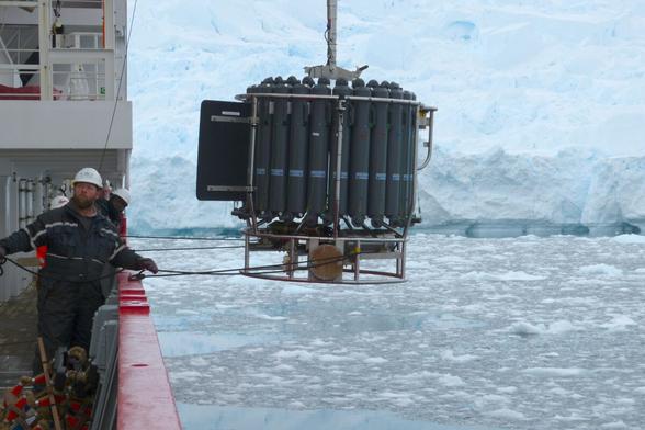
ACC = Antarctic circumpolar current. It races around the continent, mixes warm surface water with deeper cold water , hides our CO2 in the process, is also a driver in the AMOC.

So, reading that sentence, I misunderstood it to mean that it never slowed in #paleoclimate either. But if it is in part salinity-driven and if meltwater influx slows it down as the authors found in their super-high-resolution model, then surely it did happen in the past, as well.
And in a past from when ~reliable proxies would exist, if one knows what to look for, of course.
If the ACC didn't slow down during the last 1mio years, okay. Maybe, salinity and cold temperature stayed suitable then.
But from #sealevel reconstructions like Miller et al 2020, it is known that Antarctica shed and regrew a lot of ice when temperatures were higher than in the last 1mio years.

And 15mio years ago, the continent was ice free for the last time. Between then and 3mio years ago, lotsa melt & regrowth occurred, meaning lotsa periods with a potentially slow ACC in salty but too-warm waters.
What to look for tho? What else does occur and leave a footprint when ACC slows?

Ah! The mixing between ocean basins is slowed or paused.
A temperature spike in the Indian #ocean for example takes longer to propagate into the Pacific, longer than a comparable spike takes in a ACC at full-speed. Maybe a stupid example because such a spike would be too short... something else then...
ah! The Southern Annular Mode would change with a slow ACC, I bet. Maybe going from annual changes to decadal changes or such like.
And the SAM should be detectable in lake sediment in Australia. Maybe even sediment from that dry salt lake North of Adelaide that gets flooded every 50yrs or so . Maybe, with a slow ACC, that salt lake is flooded permanently - or never.
Cool.
Did researchers drill a 3-15mio year sediment core in an Australian lake?

Mongabay Environmental News · Melting Antarctic ice could weaken world’s strongest ocean current, study warnsThe strongest ocean current on Earth circles Antarctica. It’s the primary way water moves between the Atlantic, Pacific and Indian oceans, and helps regulate the global climate. But a new study suggests the Antarctic Circumpolar Current (ACC), which until now has been extremely stable, might begin to slow down in the next 25 years, with […]

Melting #glaciers caused almost 2cm of #sealevelrise this century, study reveals
Decades-long research shows world’s glaciers collectively lost 6.542tn tonnes of #ice between 2000 and 2023, causing an 18mm (0.7in) rise in global #sealevel.
Regional losses were highly variable; the Antarctic and subantarctic islands lost 2% of their volume but central Europe’s glaciers lost 39%.
36% more ice having melted between 2012 and 2023 compared with the previous decade.
theguardian.com/environment/20
#climate

The Guardian · Melting glaciers caused almost 2cm of sea level rise this century, study revealsBy Mariam Amini

I live on a beach and this is quite big.

Minimum floor levels are being raised in low-lying coastal parts of Dunedin, effective today.

When my neighbour built about ten years ago, the minimum was 0.5m. The new minimum floor level is 3.05m - 3.17m above sea level "in certain areas".

Three metres! While I approve the forward thinking, we'll have a lot of houses on poles.

Thanks to @paw for his @dccnews bot.

dunedin.govt.nz/news-and-event

www.dunedin.govt.nzChanges to minimum floor levels aim to better protect new builds from floodingMinimum floor level requirements for new homes and building extensions in low-lying coastal parts of Dunedin are set to be increased to better protect against flooding due to sea level rise.

#Oceans last year reached their highest levels in three decades — with the rate of #global #sealevel rise increasing around 35% higher than expected, according to a #NASA led analysis published Thursday... Last year's rate of average global sea level rise was 0.23 inches per year, higher than the expected 0.17 inches per year, NASA said in a news release. nasa.gov/missions/jason-cs-sen #climatecrisis

Global view of Florida
NASA · NASA Analysis Shows Unexpected Amount of Sea Level Rise in 2024 - NASALast year’s increase was due to an unusual amount of ocean warming, combined with meltwater from land-based ice such as glaciers.

#science #SeaLevel #ClimateChange

I believe climate change is a clear and present danger to planet Earth.

However, I was skeptical about a rise in sea levels being a serious issue for some strange reason.

But this NOAA/NASA article tends to make me believe sea levels rising are also a clear and present danger to all of us.

nasa.gov/missions/jason-cs-sen

Global view of Florida
NASA · NASA Analysis Shows Unexpected Amount of Sea Level Rise in 2024 - NASALast year’s increase was due to an unusual amount of ocean warming, combined with meltwater from land-based ice such as glaciers.